netconvert is able to directly read binary ArcView databases ("shapefiles"). To convert such databases, at least three files are needed: a file with the extension ".dbf", one with the extension ".shp" and one with the extension ".shx". Additionally, having a projection file with the extension ".proj" is of benefit. The option to load a shape-file into netconvert in order to convert it into a SUMO-network is named --shapefile-prefix <FILE>. Because shape-file descriptions use more than a single file, one has to supply the file name without extension, only. So, the following call to netconvert should be used to import the road network stored in "my_shape_files.shp", "my_shape_files.shx", "my_shape_files.proj", and "my_shape_files.dbf":
netconvert --shapefile-prefix my_shape_files
netconvert supports virtual file systems when
importing shape files. So if you have your shapes in myshapes.zip and the main file has the name arcview.shp
you can import them via netconvert --shapefile /vsizip/myshapes.zip/arcview (--shapefile is an alias to --shapefile-prefix).
Unfortunately, shape files describe how information is stored physically, but neither which is stored nor how the entries of the according database (*.dbf) are named. Due to this, one has to examine how a given road network is stored within the database file and give this information to netconvert; a plain call almost always fails.
Defining the Input#
The table below shows which information netconvert is trying to read from the given input files, what the standard values are, and how they can be changed. Also, it shows whether the information is mandatory - must be given - or optional.
Table: Information netconvert reads from shape-files
| Information | Mandatory | Default field name | Option |
|---|---|---|---|
| The id of an edge | y | LINK_ID | --shapefile.street-id <FIELD_NAME> |
| The street name of an edge (need not be unique, for displaying) | n | ST_NAME | --shapefile.name <FIELD_NAME> |
| The name of the node the edge starts at | y | REF_IN_ID | --shapefile.from-id <FIELD_NAME> |
| The name of the node the edge ends at | y | NREF_IN_ID | --shapefile.to-id <FIELD_NAME> |
| The type of the street | n | ST_TYP_AFT | --shapefile.type-id <FIELD_NAME> |
| Speed category | n (see below) | SPEED_CAT | |
| Lane category | n (see below) | LANE_CAT | |
| Road class, used to determine the priority | n (see below) | FUNC_CLASS | |
| Allowed speed on a road | n (see below) | SPEED or speed | --shapefile.speed <FIELD_NAME> |
| Number of lanes a road has | n (see below) | NOLANES, nolanes or rnol | --shapefile.laneNumber <FIELD_NAME> |
| Total directional road width | n | --shapefile.width <FIELD_NAME> | |
| Road length | n (see below) | --shapefile.length <FIELD_NAME> | |
| Direction of travel ("B": both, "F": forward, "T": backward) | n | DIR_TRAVEL |
If being familiar with NavTeq, you may have noticed that the defaults are the ones that are used by NavTeq.
Some shape file databases do not contain explicit information about the edges' attributes (number of lanes, priority, allowed speed) at all. It is possible to use SUMO edge type file to describe the edges' attributes. In this case, the column to retrieve an according street's type name from must be named using --shapefile.type-id <ID> and a SUMO edge type file must be given to netconvert using --type-files <FILE>. If something fails with the types or the explicit values, it can be caught using --shapefile.use-defaults-on-failure. In these cases, the default netconvert values are used. Besides this, it is possible to load own connection descriptions.
If the edge length is not specified, the length is computed based on the provided geometry.
Note
One can insert own attributes into the database using a GIS. This means, one can also insert own fields for the number of lanes, priority, or allowed speed, naming them as described above.
ArcView-networks are encoded using geocoordinates which have to be converted to the cartesian coordinates system used by SUMO. To describe how to convert the coordinates, one should know in which UTM-zone your network is located. Use projection options to set the correct one.
Caution
Road geometries must be encoded with type 'linestring'
ArcView Import Options#
The complete list of options used for reading shapefiles is given in the table below. You may find further options which control the import behavior on netconvert.
| Option | Description |
|---|---|
| --shapefile-prefix <FILE> | Read shapefiles (ArcView, Tiger, ...) from files starting with 'FILE' |
| --shapefile.street-id <STRING> | Read edge ids from column STR |
| --shapefile.from-id <STRING> | Read from-node ids from column STR |
| --shapefile.to-id <STRING> | Read to-node ids from column STR |
| --shapefile.type-id <STRING> | Read type ids from column STR |
| --shapefile.use-defaults-on-failure | Uses edge type defaults on problems; default: false** |
| --shapefile.all-bidirectional | Insert edges in both directions; default: false** |
| --shapefile.guess-projection | Guess the proper projection; default: false** |
| --shapefile.node-join-dist | Assume edges share a node if when no node id was found and their geometry-endpoints are within FLOAT m (default 0) |
Examples#
'36_NEW_YORK' from TIGER database#
The network is available from the US Census Bureau ftp server. TIGER data is freely available because U.S. Government publications are required to be released into the public domain.
Opening the edges-dbf (tl_2008_36061_edges.dbf) of which we hope that it contains information about roads shows us, that:
- the from- and the to-nodes of the streets are described in fields named TNIDF and TNIDT, respectively.
- the field tlid may be stored as the one to name the edges by
- there is a further information about the type (mtfcc)
As a begin, we try to import the road graph. We use the information we have found and apply a projection:
netconvert -v --shapefile-prefix tl_2008_36061_edges -o net.net.xml \
   --shapefile.from-id TNIDF --shapefile.to-id TNIDT --arcview.street-id tlid \
   --shapefile.use-defaults-on-failure
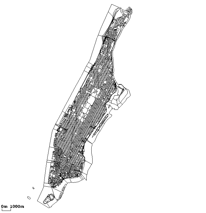
As a result, we obtain the network shown below.

Figure 1.1. The converted network of New York
There are several issues one should note:
- The types were not used - no information about their meanings was investigated
- All roads are unidirectional
- The projection has not been verified (though it should be valid)
- Maybe the further files which are included in the zip contain additional information. This has not been investigated.
'Frida' network (city of Osnabrück)#
The network is available at the Frida-homepage and is licensed under the GPL.
Our main interest is of course the street network. The following files describe this: strassen.dbf, strassen.shp, strassen.shx ("strassen" is the german word for "streets"). When opening "strassen.dbf" we have to realize that there is only a few information stored herein - neither the node names are given nor the street attributes. Instead, the street attributes seem to be stored in an additional database and are references by type names (column "strTypID" - strassen_typ_id = street_type_id). Also, the names of this database's columns have other names than expected.
Ok, let's solve these problems one after another.
-
Different field naming
The only problem with this is that we can not extract street names properly. Still, within FRIDA, the edges are numbered, and we may use the street id as name. The call has to be extended by: --arcview.street-id strShapeID
-
Missing node names
netconvert can deal with networks which do not have node names (since version 0.9.4).
-
Parsing street attributes from a SUMO edge type file
The possibility to describe edges using attributes was already available in netconvert and may be used in combination with ArcView files since version 0.9.4. Still, the types have to be translated into XML. The generated file (frida.typ.xml) looks like this:
<types>
  <!-- "noch nicht attributiert" (= not yet attributed) -->
  <type id="0"  priority="1" numLanes="1" speed="13.89"/>
  <!-- "Autobahn" (highway) -->
  <type id="1"  priority="5" numLanes="3" speed="41.67"/>
  <!-- "Bundesstrasse" (motorway) -->
  <type id="2"  priority="4" numLanes="1" speed="22.22"/>
  <!-- "Hauptstrasse" (main (city) road) -->
  <type id="3"  priority="3" numLanes="2" speed="13.89"/>
  <!-- "Nebenstrasse" (lower priorised (city) road) -->
  <type id="4"  priority="2" numLanes="1" speed="13.89"/>
  <!-- "Weg" (path) -->
  <type id="5"  priority="1" numLanes="1" speed="5"/>
  <!-- "Zone 30" (lower street with a speed limit of 30km/h) -->
  <type id="6"  priority="2" numLanes="1" speed="8.33"/>
  <!-- "Spielstrasse" (a street where children may play (10km/h)) -->
  <type id="7"  priority="1" numLanes="1" speed="1.39"/>
  <!-- "Fussgaengerzone" (pedestrains zone) -->
  <type id="8"  priority="0" numLanes="1" speed="0.1"/>
  <!-- "gesperrte Strasse" (closed street) -->
  <type id="9"  priority="0" numLanes="1" speed="0.1"/>
  <!-- "sonstige Strasse" (something else) -->
  <type id="10" priority="0" numLanes="1" speed="0.1"/>
  <!-- "Fussweg" (way for pedestrians) -->
  <type id="11" priority="0" numLanes="1" speed="0.1"/>
</types>
The call has to be extended by: -t frida.typ.xml --arcview.type-id strTypID
After having applied all those changes, the network was buildable, but looked quite messy. After having played with geocoordinate projections, this was fixed. So the call (so far) looks like this:
netconvert --arcview strassen -o frida.net.xml \
  --arcview.street-id strShapeID -t frida.typ.xml \
  --arcview.type-id strTypID --use-projection
Data Quality#
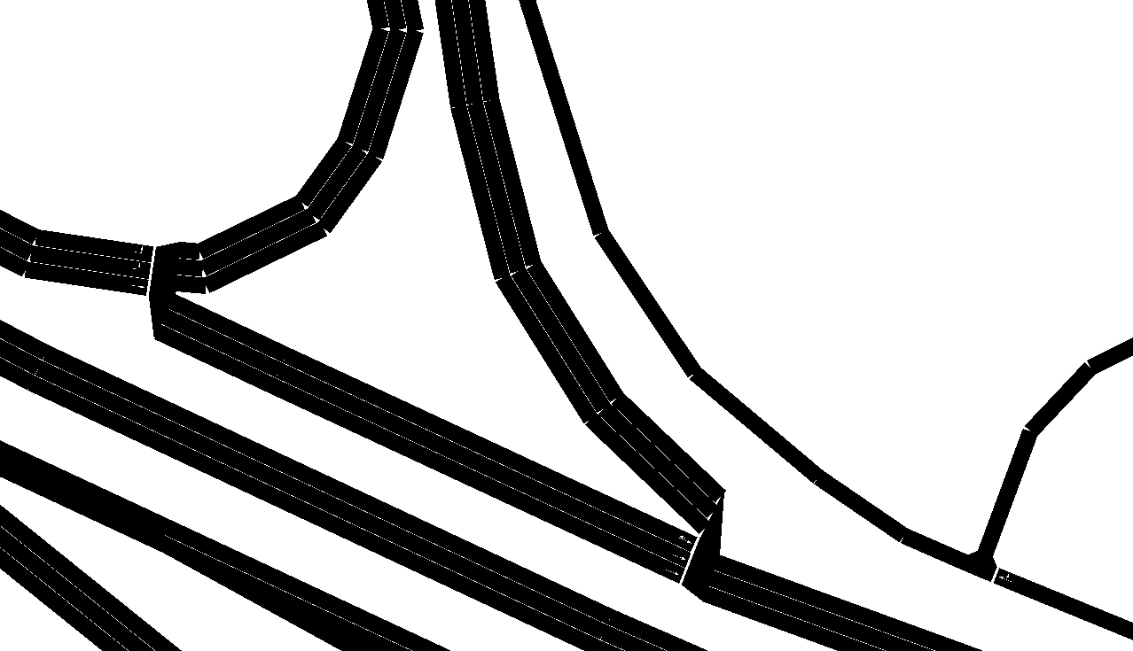
Looking a bit deeper at the network, we had to realise two further problems. At first, highway on- and off-ramps are marked as "highway". this yields in a network where on- and offramps have the same number of lanes as the highways themselves. And it's definitely not fitting to reality, as the next picture shows:

Figure 2.2. Detail view showing problems with (unidirectional) highway on-/off-ramps
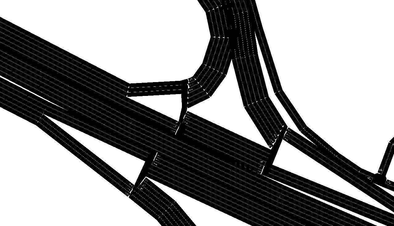
Furthermore, all streets are unidirectional - even highways. This makes the network not usable for traffic simulations when left in the original state. Trying to convert the network with --arcview.all-bidi, that means trying to insert edges bidirectional, makes the city usable, but the highways are even worse, now, because also the on-/off-ramps are bidirectional, then...

Figure 2.3. Detail view showing problems with (bidirectional) highway on-/off-ramps
Demand#
There is no demand available for Frida - at least none we know about.
Conclusion#
Using the current features we are able to parse the network from the Frida-project but we can not state it is completely usable for traffic simulations. At least areas around highways are not realistic, because on-/offramps lack an explicit declaration and are due to this as wide as the highways themselves. Furthermore, all streets within the network are coded in just one direction. Extending them to be bidirectional solves the problem in inner-city areas, but yields in an unacceptable result for highways.
 This work is licensed under a Creative Commons Attribution-ShareAlike 3.0 Unported License. The authors are listed in the history.
